
Home / Projects
Flagship Projects
Three stories that show how Beacon works: a national positioning network, its extension down the Nile, and a century-old lighthouse given a new light.
1997 → today · Egyptian Ports & Lighthouse Authority
Egypt National Marine DGPS
In 1997, Beacon Co. of Egypt and the Maritime Systems Business Unit of MacDonald Dettwiler (formerly the Maritime Information Systems Group of CANAC/Microtel) were awarded a contract to provide a complete turnkey national DGPS system for the Egyptian Ports & Lighthouse Authority. The contract covered engineering, procurement, integration, factory testing, delivery, configuration and site testing of the Egyptian Marine DGPS.
System architecture
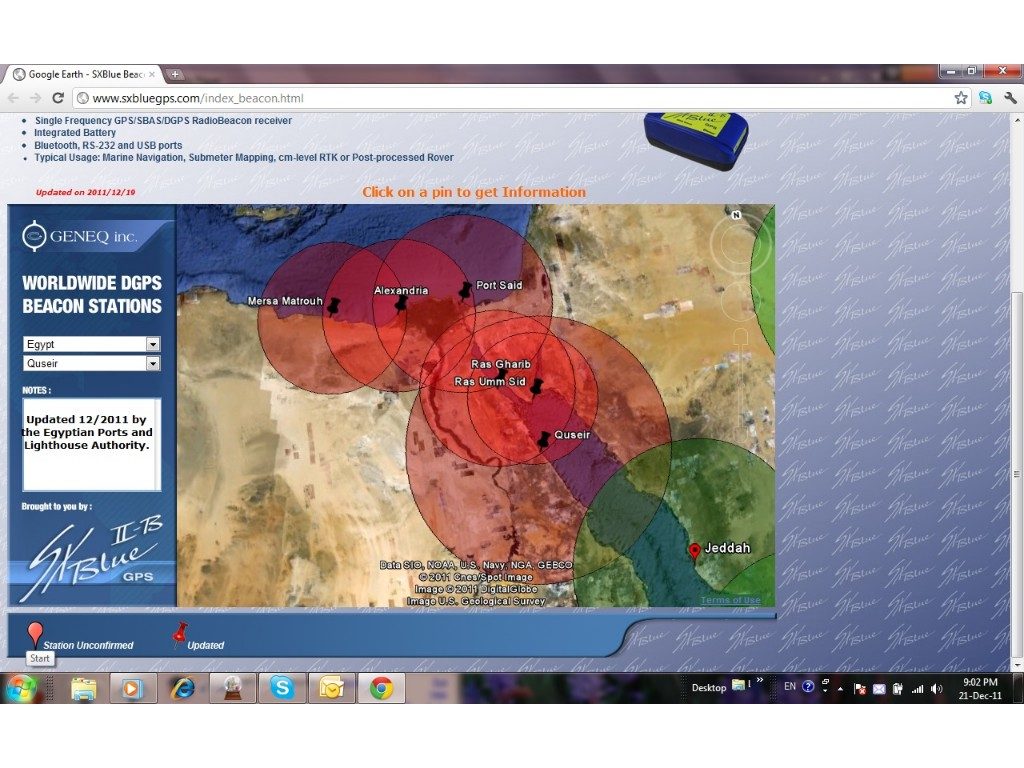
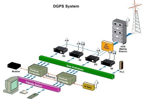
The system consists of one control monitor station linked to six DGPS control stations via an HF radio network, with backup access over standard telephone lines. Each control station broadcasts DGPS corrections on a standard marine radio-beacon frequency as a supplement to GPS — letting Egyptian and international mariners fix their position to better than 5 metres, a huge improvement over the roughly 100-metre accuracy of uncorrected commercial GPS of the era.
The network implements a fault-tolerant architecture with dual redundancy in all key equipment: if any element fails, the system keeps operating, and every irregularity is reported immediately to the control monitor.
Reference data
Egypt Marine DGPS station data
| Site | Machine name | Station ID | Range (km) | RS IDs | Freq (kHz) | Baud (bps) |
|---|---|---|---|---|---|---|
| Port Said | Port Said 1 / 2 | 321 | 324 | 442, 443 | 290.0 | 200 |
| Alexandria | Alexandria 1 / 2 | 320 | 278 | 440, 441 | 284.0 | 200 |
| Mersa Matrouh | Mersa 1 / 2 | 324 | 278 | 448, 449 | 307.0 | 200 |
| Ras Umm Sid | Rasummsid 1 / 2 | 322 | 234 | 444, 445 | 293.5 | 200 |
| Ras Gharib | Ras Gharib 1 / 2 | 323 | 278 | 446, 447 | 298.0 | 200 |
| Quseir | Quseir 1 / 2 | 325 | 482 | 450, 451 | 314.5 | — |
Technology
How Differential GPS works
A Differential Global Positioning System improves accuracy by using a reference GPS receiver at an accurately surveyed point. By comparing the known coordinates with the position the satellites predict, satellite range corrections can be determined and broadcast in real time over a radio link — and nearby users apply those corrections to sharply improve their own fix.
This removes most of the errors inherent in standard positioning: satellite clock error, ephemeris error and ionospheric noise. Corrections are broadcast continuously in the internationally accepted RTCM SC-104 format, free to receive for any suitably equipped vessel, and work in all areas and all weather. Reference stations also monitor their own broadcast, providing real-time quality analysis and integrity warnings — users with differential-equipped receivers see their position error fall to well under 10 metres.
River Transport Authority · with Frequentis
Nile DGPS — Cairo to Aswan
Beacon was the prime contractor — and its maintenance contractor for two decades — for Egypt's DGPS network delivered to the Egyptian Authority for Maritime Safety in 1998. On the strength of that record, Frequentis, prime contractor for the RTA Nile River Information Services project, asked Beacon to design and build a DGPS along the Nile between Cairo and Aswan.
Marine-beacon DGPS uses non-directional transmitters in the 300 kHz band to broadcast corrections over several hundred kilometres. Egypt has had a working network since 1998 covering both the Mediterranean and Red Sea coastlines and the length of the Suez Canal — so the same proven technology was proposed to serve vessels navigating the Nile.
Performance specification
- Marine-beacon DGPS system, similar to the EAMS coastal network
- Dual reference receivers with integrity monitor at every site
- Accuracy better than 3 m across the coverage area · 2DRMS (95%)
- Coverage of over 95% of the Nile from Cairo to Aswan with a maximum of 4 sites
- Two far-field monitor sites; power backup for 24-hour response
- Technical and user training, plus documentation to Beacon standards
The four unmanned sites are joined in a virtual private network, remotely configurable from a central control-monitor interface. Each station receives the GPS signals, computes pseudo-range and range-rate corrections against its precisely known location, assembles RTCM messages and broadcasts them by MSK modulation in the 283.5–315 kHz band at 200 bps — monitoring its own transmission and issuing integrity alarms the moment anything drifts out of tolerance, in compliance with RTCM SC-104 RSIM.


Custom solution · Gulf of Suez
Ras Zafarana Lighthouse re-light
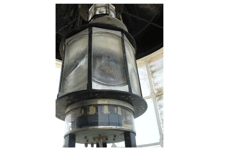
Ras Zafarana's original optic — a cut-and-polished lens on a lamp-changer pedestal with its vintage drive motor and mercury bath — had reached the end of the line: spares for the pedestal were obsolete, yet the station's luminous range of not less than 16.8 nautical miles (at T=0.74) had to be preserved.
Beacon's answer replaced the pedestal entirely, removed the mercury bath, and manufactured a purpose-built adapter plate so the new light assembly could mount directly in place of the old.
The new light system
- PRL-600 pedestal — mild steel, nickel plated — matching the original light character
- New 8-panel moulded-glass lens in aluminium frame · focal length 360 mm
- Effective intensity ≈ 30,000 cd · luminous range 16.8 nm @ T=0.74
- Character FL W 10s · flash 0.15 s · rotation 0.75 rpm
- Pelangi PRL-400 rotating beacon as standby, rated for 24 h/day duty
- New PRB-400 standby light and complete new control supply
See the work in pictures
Installations, factory acceptance tests and lighthouse refurbishments — documented in the field.